


介绍 Horizon Explorer AR
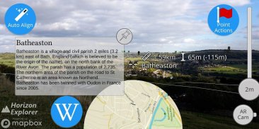
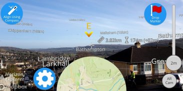
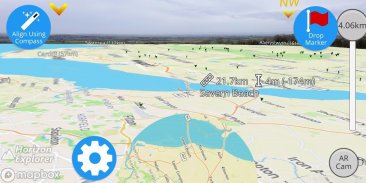
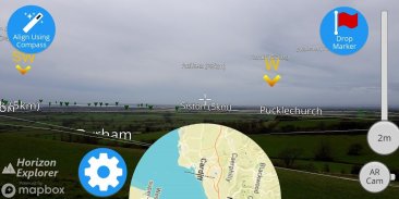
Point your camera at a landmark you can see on the horizon (eg. Hill, Mountain, Road, Lake, Building) and see:
- Name of the landmark
- Distance from you
- Altitude (& relative to you)
- Map of surrounding area
- Nearby towns and cities
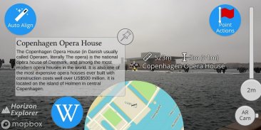
- Wikipedia info for any landmark with a Wikipedia page
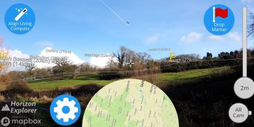
- Direction from you (eg. Northwest)
- Directions to landmark (opens in google maps)
- Street view for where you're pointing (opens in google maps)
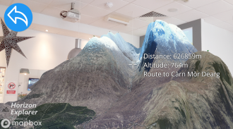
Or use 3D Map mode:
- See terrain laid out in front of you
- Move phone to fly around the map
- Roadmap / satellite / hybrid
- Search & display 3D-maps for anywhere worldwide
- Distance, altitude and landmark names
- Infinite scroll
Horizon Explorer works worldwide, but works best on top of a hill with an unobstructed view of your surroundings. You can drag the horizon line with your finger to line up with the camera if the automatic tracking is not working very well. Or try waving your phone around in the air in a figure 8, then pressing "align using compass" to calibrate the compass.
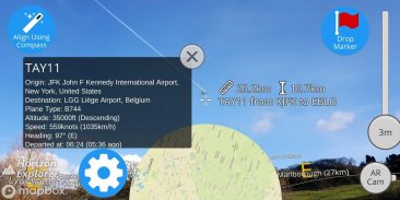
Live airplanes can also be enabled, starting from $0.99. Point at a plane and see the flight number, origin, destination, altitude and current airspeed of any commercial airline plane you can see.
If you are in a tall building, or otherwise not standing on the ground, enable "Tall Building mode" and optionally set your altitude using the slider.
Horizon Explorer will show mountain names, lakes or forests, the names & designations of roads, and many buildings.
Wikipedia Information will be displayed for anything that has an English Wikipedia article with a location set.
This app uses Google's ARCore to do augmented reality. This technology is currently available on ~50 phones: https://developers.google.com/ar/discover/supported-devices
If you don't already have the latest ARCore app installed, you will be prompted to install / update it from the Play Store when you first open Horizon Explorer.
将相机对准您可以在地平线上看到的地标(例如,山,山,道路,湖泊,建筑物),并查看:
- 地标的名称
- 距离你的距离
- 海拔高度(相对于你)
- 周边地区的地图
- 附近的城镇
- 维基百科页面上任何具有里程碑意义的维基百科信息
- 来自你的方向(例如西北)
- 地标方向(在谷歌地图中打开)
- 您指向的街道视图(在谷歌地图中打开)
或使用3D地图模式:
- 查看摆在你面前的地形
- 移动手机在地图上飞行
- 路线图/卫星/混合动力
- 搜索和显示全球任何地方的3D地图
- 距离,海拔和地标名称
- 无限滚动
Horizon Explorer可在全球范围内使用,但在山顶上工作效果最佳,可以一览无余。如果自动跟踪功能不正常,您可以用手指拖动水平线与相机对齐。或者尝试在图8中在空中挥动手机,然后按“使用罗盘对齐”来校准指南针。
现场飞机也可以从0.99美元起启用。指向一架飞机,查看您可以看到的任何商业航空公司飞机的航班号,起点,目的地,高度和当前空速。
如果您在高层建筑中,或者不站在地面上,请启用“高层建筑模式”,并可选择使用滑块设置高度。
Horizon Explorer将显示山名,湖泊或森林,道路的名称和名称以及许多建筑物。
维基百科信息将显示任何包含具有位置集的英语维基百科文章的信息。
这个应用程序使用谷歌的ARCore来做增强现实。该技术目前可在约50部手机上使用:https://developers.google.com/ar/discover/supported-devices
如果您尚未安装最新的ARCore应用程序,则在首次打开Horizon Explorer时,系统将提示您从Play商店安装/更新它。
Horizon Explorer AR - 版本1.23.0
(23-04-2020)Horizon Explorer AR - APK信息
APK版本: 1.23.0程序包: com.arrowsd.horizonexplorer同类应用
您可能还会喜欢……


